After a long day of driving, we reached Mount Cook National Park in time to see Mount Cook in the fading light. It turned out that this was the last chance we had to see Mount Cook. It rained for the next few days we were in the park. The low cloud cover and drizzle meant that we never got another clear look at the peak.
Rather than waste the long drive into the park, we decided to hike despite the rain. We picked the Hooker Valley trail which goes along the banks of a glacial stream, switching from one bank to the other over a series of
suspension bridges and ends at a lake formed at the face of the glacier. As we hiked under an overcast sky with the rock rubble of the moraine underfoot, I thought that this must be what it is like to hike through Mordor. There was even an appropriately shaped pile rocks that looked like Mount Doom.
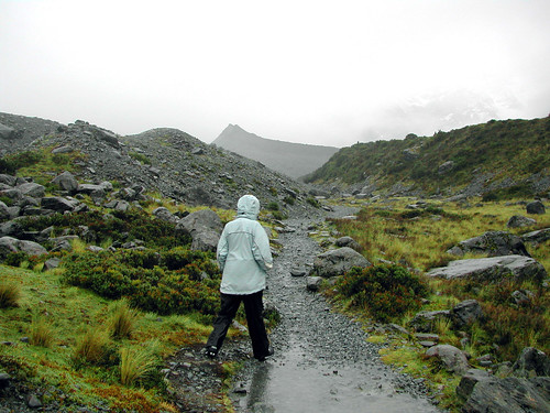
The pic shows LC on the Hooker Valley trail in full combat gear: waterproof coat, boots and rain pants. We needed every bit of gear we had, especially the boots, as the continual rain turned the path into a little stream with clear, cold flowing water. As we neared the end of trail, the valley walls started to narrow which was worrying because of the avalanche danger. As we hiked we heard the occasional growling bass rumble of falling rocks or ice, sounding oddly muffled in the drizzle and low cloud of the valley.
We eventually reached a sign on the trail which warned of possible avalanche danger beyond that point. After some debate, we decided to push on as we must be very close to the lake. No sense turning back when we were so close. We eventually reached the lake, and glimpsed the face of the glacier dimly in the mist at the far end.
This pic shows LC, at the lake looking happy and very cold at the same time. You can see icebergs in the water which have calved from the face of the glacier. The water in the lake is milky due to the grit and pulverized rock from the melted glacier.
We didn't linger in the avalanche zone and soon headed for the long tramp back to the trail head.